
From Hut To Hut Through Limestone Peaks
A taste of Italy as tested in Wanderlust Europe
Northern Italy’s mountainous areas cover such a vast portion of the country that it can be hard to know where to start. Between the Maritime Alps and the big peaks of the Aosta region in the west, and the eastern Dolomites toward Austria and Slovenia, you’ll find the Dolomiti di Brenta—a compact massif west of Trento and the Valle dell’Adige. It may be dwarfed by bigger areas such as Ortles, but this is a fantastic place for hut touring in big mountains.
This is thanks in part to its geography. Like much of the Dolomites, the Brenta range is punctuated by dramatic, soaring towers of rock, and many summits reach the magic 3,000m (9,843 ft) contour. Although the rock here is mostly dolomite, rather than the limestone of Tre Cime di Lavaredo, this is still a dry landscape of karst formations—rainwater doesn’t stay on the surface for long, but soon finds its way underground and often doesn’t reappear until several hundred meters downhill.

The Western Brenta Circuit takes adventurers on a 12mi (19km) trail that takes roughly one-to-two days to complete. This is a moderate hike that consists towering summits and rocky paths. (Photo: imageBROKER/Alamy Stock Photo, Wanderlust Europe)
One such dramatic reappearance takes place at the Cascate di Vallesinella near Hotel Vallesinella a few kilometers southeast of the ski resort of Madonna di Campiglio. The Cascate Alte is one of the most impressive waterfalls in the valley, and one of the best walking tours in the Brenta Dolomites passes right next to it.
This route was created by British travel writer Gillian Price, a leading English-language expert on walking and traveling in Italy. A resident of Venice, Price has spent years wandering throughout the Dolomites and other parts of the Alps conducting research and has published over a dozen guidebooks on trekking in Italy. While many of the routes featured in this book are national trails or have otherwise been on hikers’ radars for many years, this is one of the few walks featured that has come to recent prominence thanks to an individual writer. Of course, hikers and climbers have been enjoying the trails that make up the Western Brenta Circuit for a long time, but guidebooks provide context and structure for how we enjoy the mountains.

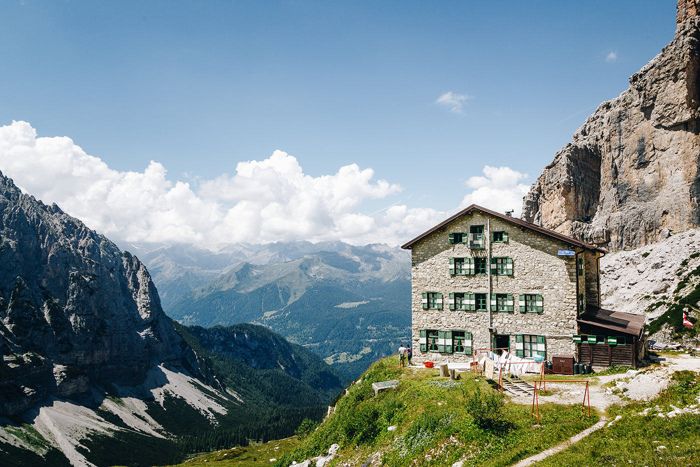
The Brenta area was developed as a center for hiking, trekking, and mountaineering several decades after the main chain of the Alps. John Ball, founder of the Alpine Club and a prominent Irish naturalist and mountaineer, traversed the range via the Bocca di Brenta, a high pass that can be accessed from Rifugio ai Brentei. Infront is a grand view of Cima Tosa on the way to Rigugio ai Brentei. (Photo: Paul Healy, Wanderlust Europe)
Although this hike visits no high peaks, it’s still compelling. Strong walkers could make it in a day with an early start, but why hurry? Far better to spend the night in a refuge and take your time. The walk begins at Hotel Vallesinella and climbs through pine forests before breaking out onto a rock-strewn mountainside with fantastic views of the Brenta Dolomites. To the right is Fracinglo’s dramatic ridgeline, while dead ahead is the cluster of peaks around Cima Tosa at 3,133m (10,279 ft), the second-highest summit in the massif. Its north face is split by a couloir known as Canalone Della Tosa—a famous ice-climbing route that used to be practical in June, but is now dangerous in the summer season, thanks to climate change. The first hut, Rifugio ai Brentei, is visible in front of the peak, and the trail climbs gradually up to this refuge, following the Sentiero Bogani balcony path that heads straight across seemingly vertical cliffs. At 2,182m (7,159 ft), Rifugio ai Brentei marks the endpoint for the first day’s hike, though Gillian Price recommends an extension to the higher Rifugio Alimonta.
The next day, return along the Sentiero Bogani to the path junction and then head east toward Rifugio Tuckett e Sella. This hut, which makes a good place to stop for lunch, is directly beneath the mountain walls of Cima Brenta and Cima Sella, and here the route veers north into a barren karstic landscape of scree and rocky slabs. The route soon descends to Rifugio Graffer, a busy spot near the ski area, and then descends more steeply back toward Vallesinella. The views on the descent are excellent, offering a broad panorama over Cima Grostè and the other peaks of the Brenta range. You’ll soon pass back into the forest and visit the huge waterfall of Cascate Alte on your way back to Hotel Vallesinella.
Good To Know
Start: Hotel Vallesinella, Trentino, Italy
Total elevation gain: 1,133 m (3,717 ft)
Season
June, September, or October. These trails are usually well clear of snow by late May or early June. As in other parts of the Dolomites, July, and August are the busiest months.
Accommodations
Hotel Vallesinella, where the route begins and ends is a modern three-star hotel in a splendid setting. There are four mountain huts along the trail: Rifugio Casinei, Rifugio ai Brentei, Rifugio Tuckett e Sella, and Rifugio Graffer. Book well in advance. Wild camping is not allowed.
Highlights
1. The view of Cima Tosa’s north face
2. The Sentiero Bogani balcony

Looking over the peaks of the Western Dolomites. Most of the peaks in the Brenta were first climbed over 20 years, starting with the Cima Tosa in 1865. The last major peak, Campanile Basso, was finally climbed in 1899. (Photo: Maja Kochanowska, Wanderlust Europe)
Helpful hints
What to bring
Pack a lightweight daypack with the usual essentials: warm layer, waterproofs, water bottle, snacks, sunscreen, sun hat. A sleeping bag liner is required for staying in the huts.
Footwear
Lightweight mesh trail shoes may be preferred by some on this hike, though there’s a great deal of rough and rocky ground, including some exposed ledges. Many walkers may prefer the stability offered by hiking boots.
Planning and navigation
As in other parts of the Dolomites, all paths are well signposted and navigation is very easy. The topographic map you’ll need for this area is the Tabacco series 1:25,000 sheet 053 (Dolomiti di Brenta).
Supplies
There are full options for resupplying in the nearby town of Madonna di Campiglio. The refuges along this trail all offer meals and snacks for hikers.
Water
Once you’re above the forest and into the karst, there are few natural water sources, but you can fill your bottles at the huts. Make sure you carry enough water if the weather is hot.
This story was originally written by Alex Roddie and featured in Wanderlust Europe.

